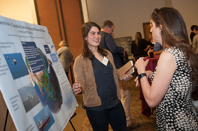
The Spatial Learning, Research, and Community Service Symposium last week celebrated the work of students, faculty, and administrators in University of Redlands programs.
Here are some remarks from the event:
“We’re very proud of the collective spatial and GIS-infused work that takes place here at the University of Redlands. We are one of the only universities with an extensive integration of spatial thinking, GIS research and teaching, and applied GIS across undergraduate, graduate, and professional education, as well as administrative functions.”
—Provost Kathy Ogren, in her talk, “A Week in the Life of a Spatial University”
“I have decided I really love teaching. I really love showing people what can happen, what can be done, and what kind of decisions you can make based on information. It has been quite an experience building this project with the help of my professors.”
—Sarah Griffin ’19, MBA with marketing emphasis, presenting her poster, “A Model for Big Data and Location Analytics Infusion in Business Curricula”
“What we are really celebrating tonight is how we plan to change the world with mappers, not maps. We train GIS analysts who can apply their liberal arts knowledge [and] broad perspective. We give practical work experiences in spatial internships. We teach cutting-edge techniques such as mobile data collection for ArcGIS. We help students tap into skillsets and qualifications that are in high demand, such as piloting drones ... We connect students with partners, such as our friends at Esri.”
—Steven Moore, director, Center for Spatial Studies, in his talk “Changing the World with Maps”
“Basically, I had the opportunity to create a complete GIS framework to automate a disaster response workflow for health agencies, with the guidance of my professors. The Esri team also was a very good resource—those guys are amazing! They are always willing to help. I have been working with Health and Human Services Team at Esri, making presentations to different health agencies every two weeks. The relationship between the University and Esri is great!”
—Cesar Garrido Lecca ’18, MS in geographic information science (GIS), presenting “GIS for Rapid Health Assessment: From Collection to Analysis After a Disaster”
“The idea is we are using spatial analytics to make change. We are trying to make positive change in organizations, industries, nonprofits, and government—that is, in society. In order to do that, we have to take these spatial tools and think about what difference they can make in creating business and societal value and who needs to act on this information to make that difference. That’s really the essence of our spatial business initiative.”
—Tom Horan, Senecal Endowed Dean of the School of Business, in his talk, “Training Spatial Business Transformers”
“The [LA River Project] group was really excited about having us do a GIS project for them because they didn’t have the spatial resources to do it otherwise. This project allowed partners to see what others were working on. People don’t necessarily know each other or if they are working on similar projects. If they are working on similar projects, this allows them to see that, get in contact with each other, and collaborate.”
—Shayla Funk ’18, undergraduate environmental science and public policy major, presenting “Urban Water Federal Partnership LA River Project”
“Scientists are used to communicating in this inverted triangle. When you write your thesis or a paper, you start with all this background, the literature review, and everything that is known. And you drill down to what you are contributing, what your supporting details are, and finally to the result. Many of us now in the scientific community—including those of us in geography, the geographic information science world, the geospatial data science world—we are learning now we must invert this triangle, particularly if we are going to talk to policy makers ... to get them to really understand what the crux of the matter is. What is the result that we have obtained? Bring that out first. Why is that result important for the community or for society? What is the public good associated with that? And then, if there is time or if the policy maker or journalist or whomever you are talking to has the interest or staff, you can go into all the supporting details.”
—Dawn Wright, chief scientist, Esri, in her talk, “The Courage to Communicate”
“What was most interesting about our Airbnb Premier Project was that in the end, after we were able to produce it, Airbnb launched a similar product, thus proving that our academic GIS research has real value in the industry. We have presented this project in the classroom, to an audience at the Los Angeles Geospatial Summit, and at today’s Spatial Symposium. It has been very rewarding to network and share our ideas with the community.”
—Karisa Schroeder ’18, MBA with Location Analytics concentration, presenting a project and story map co-created with Scott Daly ’18, MBA with Location Analytics concentration, “Airbnb Premier: Ile-de-France, Paris; A GIS Business Proposal”
For more information on the spatial studies programs at the University of Redlands, see A Spatial University.